This post has several suggestions regarding the “1 Terminal” project concept (and rezoning application), with particular focus on public space opportunities. This post does not address other, ever present, concerns such as affordability, carbon-negative targets, and first-nations’ concerns.
As a local citizen with a long-standing interest in liveable public space, I am concerned about several aspects of the 1 Terminal project. Some simple changes would greatly improve the usability of the space and would not be onerous. I am presenting these suggestions for improving pedestrian & cycling connections, increasing the public space along the riverfront, and enhancing the site’s most public edges.
References (City of Nanaimo):
Rezoning Application (RA000475),
Rezoning Application Report,
Public Hearings Info
I request that the City of Nanaimo include the following conditions for approval of this rezoning application.
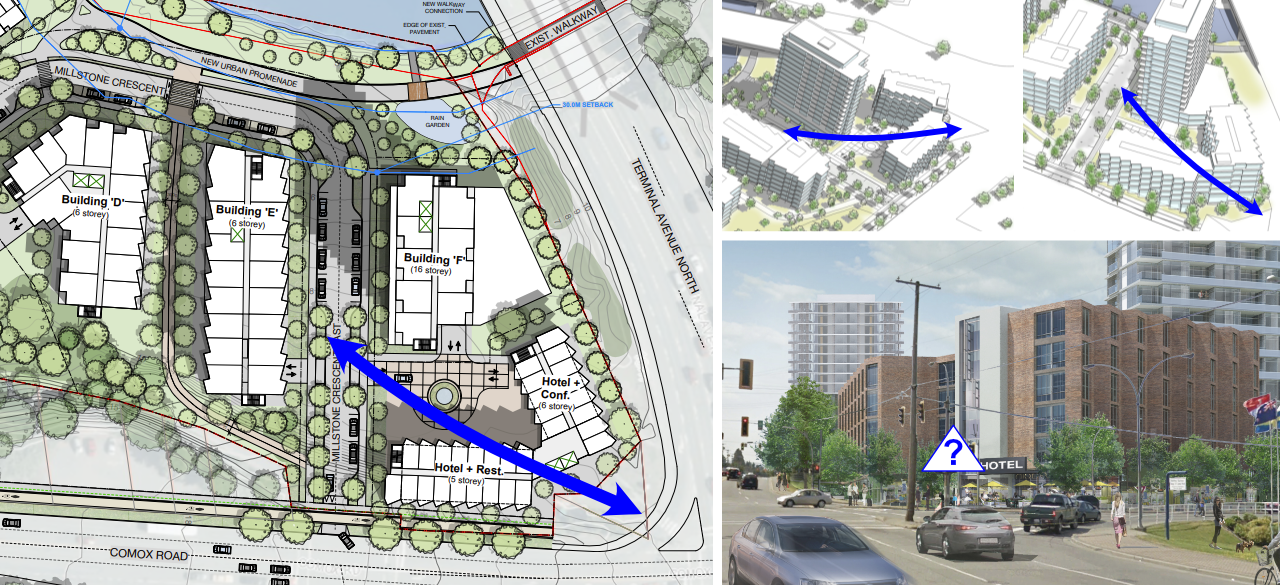
Probably the easiest to achieve, is the identification & realization of desire-lines. Two desire-lines in particular seem clear.
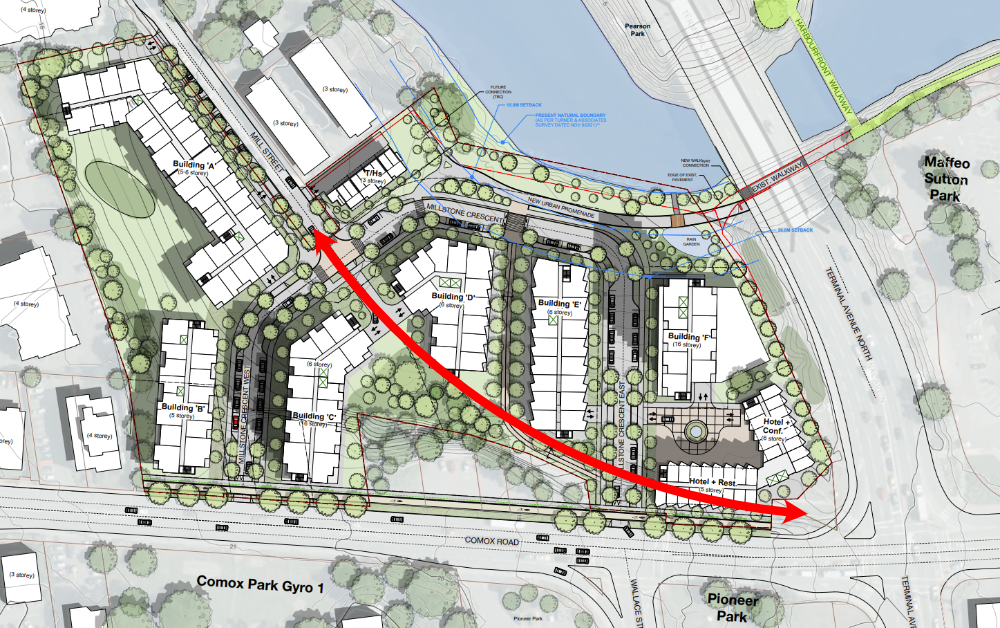
One of the significant desire-lines is the connection from the main intersection, and the rest of downtown, to Mill Street – which is itself a connection to the E&N Trail. The project concept provided in the rezoning application already has an open space that would easily allow for a pedestrian/cycling path along this axis.
The planned sidewalk and bike lane along Comox does not allow for a smooth and intuitive connection to Mill Street. Desire-lines are routes that pedestrians & cyclists will seek out whether or not designed for.
Designing for these desire-line paths creates a more intuitive network of connections that people will find easier to understand and make use of. Allowing visitors, and citizens unfamiliar with the area, the ability to intuitively find their way through the site.
Note that the City of Nanaimo has added a requirement for a path between Buildings D & E (as can be seen on the concept drawings, and mentioned in the report); similarly the City can require this additional path connecting Mill Street in the conditions for rezoning.

Another very likely desire-line, that people will forge themselves if it isn’t provided for, will be the connection from Terminal Ave down to the riverfront. This connection currently exists and is an obvious and direct path presented to anyone standing on Terminal (or at the intersection).
A path parallel to Terminal, connecting the street & intersection to the riverfront, appears to fit easily into the existing plan. Much of the space between the 1-Terminal project’s land and Terminal Ave is already a City owned right-of-way.
See also the active-frontage suggestion later in this document, regarding enhancing the ground-level use along the Terminal Ave frontage.
This path should be a direct connection from the intersection (and Terminal Ave) to the riverside path. The desire-line is a direct route to the riverside path and should not require a detour (west along the site to the currently proposed entrance point onto the riverside path). We should be making pedestrian & cycling connections easy, not forcing people to take detours. The currently proposed site slope may create complications for this connection, in the worst case scenario I believe stairs would allow for this direct-connection, however a sloping interface would greatly improve the functionality of the path and site in general – especially for cyclists and the mobility-challenged.
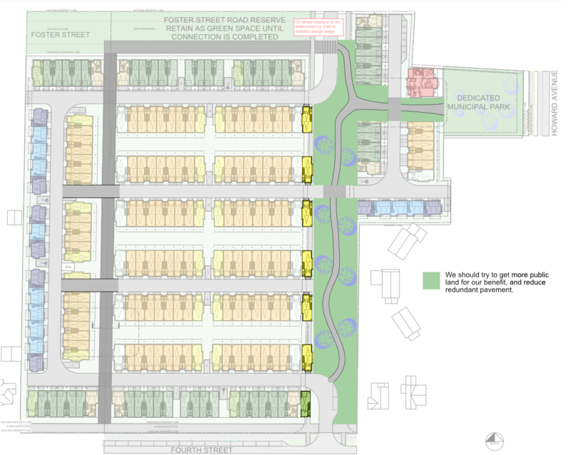
The “1 Terminal” concept could be adjusted to allow for additional public park space, while also fixing the barrier presented by the grade separation between the site and the riverside path.

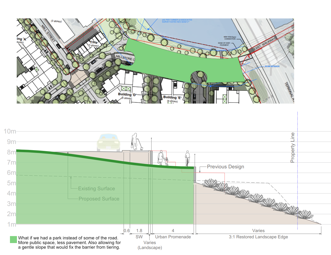
Removing the central portion of the Millstone Crescent street, along the river (as illustrated), would allow for a significant increase in public park space and allow for the landscape to roll gradually down to the riverside path rather than requiring a grade separation. This grade separation (as presented in the concept) creates a barrier to movement, reducing usable space, and allows for movement only along the designated route.
The potential for this riverside site is much more. Removing the grade separations and creating a sloping gradient would open the space for use as a public place, more than just a transit route. It would also create a friendlier and safer pathway, with the removal of the grade separating wall.
The current grade separation also prevents people from connecting through the site as desired. As an example, a person who walks from Maffeo-Sutton Park under the overpass could not immediately head up into the site, but rather has to continue further to where the grade separation allows it. This also makes other connections more difficult, including the desire-line from the north-east corner of the site up to the intersection of Terminal & Comox.
The elimination of through-traffic along the riverfront would not cause any issue with regards to connections, as there seems to be little need for traffic to flow through that section of street considering the neighbourhood layout and other streets available.
The resulting through-traffic reduction would create a calmer, safer, and more pleasant space for residents and visitors to enjoy.
I recommend changes to the project plan allowing for a gradual slope down to the riverfront path along the entire northern site, enabling increased public space as well as a safer and more useful riverfront pathway. In particular, the elimination of the grade separation between the riverside path and the rest of the site is important for connectivity and creating a comfortable public realm.
Notably, the City of Nanaimo is not applying the 30 meter riparian setback to this site; however we should be seeking to use this space for public and environmental benefit rather than non-integral automobile traffic.
This project could provide greater ground level opportunities, including commercial and live-work units, particularly along the site’s most public edges.
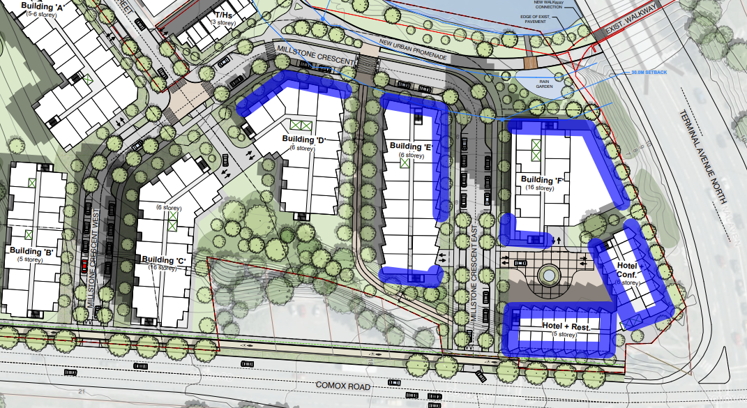
The project concept does not make it clear what the ground level usage will be, but I am concerned about the lack of active-frontage on this site, particularly on the most public edges of the site.
The ground level units along Terminal, on Comox near the intersection, along the riverfront and possibly some inner corners, could be a successful mix of commercial and live-work units. This would allow for a better transition from the downtown district, as well as making use of this prime property along the river.
Furthermore, the intersection corner could be opened up to invite connection into the site rather than being a barrier to pedestrian traffic. The hotel might be designed as a component within a commercial corner leading people into the site and down to the river. Shops, restaurants, and the like would create a more livable neighbourhood and a more interesting city.
Imagine walking down through a future downtown, into this site and having lunch from a shop on a riverside park.